Listeners:
Top listeners:
-
 play_arrow
S1 E9 | Are We That Incompetent? Canada vs Saudi Arabia
-
 play_arrow
S1 E2 | Milk, Markets, and the Cost of Protection
Bomb cyclone disrupts North America as extreme cold grips Canadian cities coast to coast
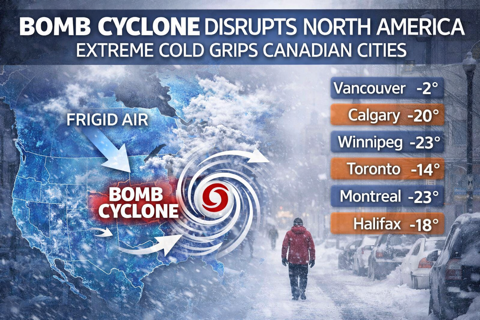
A powerful bomb cyclone sweeping across North America is bringing widespread disruption to travel, infrastructure, and daily life, while pushing dangerously cold Arctic air deep into Canada, affecting major cities from coast to coast.
A bomb cyclone, formally known as bombogenesis, occurs when a storm rapidly intensifies, with atmospheric pressure dropping sharply in a short period of time. This rapid strengthening fuels powerful winds, heavy precipitation, and abrupt temperature swings. In the United States, the current system has triggered flight cancellations, highway closures, and power outages across large sections of the Midwest, Great Lakes, and Northeast.
While much of the storm’s most severe impacts are being felt south of the border, Canada is experiencing the other side of the system: a surge of Arctic air plunging temperatures well below seasonal norms.
In Western Canada, cities such as Vancouver and Victoria are seeing colder-than-usual conditions, with overnight lows dipping below freezing and snow possible in areas that typically see rain. The Prairies are bearing the brunt of the cold, with Calgary, Edmonton, Regina, and Winnipeg experiencing frigid temperatures and wind chills reaching dangerous levels, particularly overnight and in open areas.
Across Central Canada, the cold has tightened its grip. Toronto, Ottawa, and Montreal are seeing daytime highs remain well below freezing, with overnight lows plunging sharply. Wind chills are making conditions feel significantly colder, prompting cold weather warnings and advisories. Officials are urging residents to limit time outdoors, dress in layers, and check on elderly neighbours and those without stable housing.
In Northern Ontario and Quebec, temperatures are even more extreme, with prolonged cold increasing the risk of frostbite in minutes. Schools, transit agencies, and social services are adjusting operations to account for the cold snap.
Further east, Atlantic Canada is also experiencing below-normal temperatures, though coastal areas are seeing slightly moderated conditions compared to inland regions. Strong winds associated with the broader system are contributing to hazardous marine conditions and reduced visibility at times.
The cold air mass is expected to remain entrenched through the weekend, with only gradual moderation early next week. Meteorologists note that while January cold snaps are not unusual, the breadth of the current system and its alignment with a major storm pattern over the United States make this event particularly impactful.
Transportation networks across Canada are being monitored closely. While snowfall amounts are generally limited in many regions, extreme cold can affect rail operations, aviation performance, and road safety, especially when combined with gusty winds.
Emergency services and municipal governments are reminding residents to take precautions, including keeping vehicles winter-ready, carrying emergency kits, and avoiding unnecessary travel during the coldest periods.
Although temperatures are forecast to slowly ease in parts of southern Canada by early next week, forecasters warn that winter is far from over. The current system serves as a reminder of how interconnected North American weather patterns can be, with a single rapidly intensifying storm capable of producing dramatically different impacts across the continent.
For now, the message remains simple: stay warm, stay informed, and prepare for winter conditions to persist.


Post comments (0)