Toronto | North of The City
Why Bill 76 Quietly Rewrote Barrie’s Borders : And What It Means for Your Next Property Tax Bill

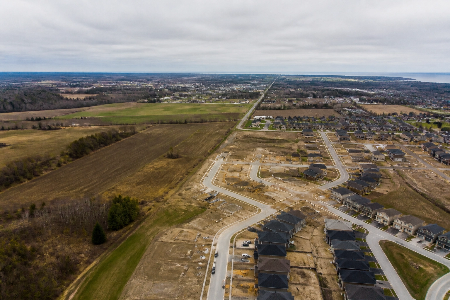
For most residents across Simcoe County, the final weeks of 2025 passed in a blur of holiday preparations and winter weather tracking. But while the public was looking away, provincial legislators and municipal halls quietly finalized one of the most significant jurisdictional realignments in central Ontario's recent history.
Enacted following months of closed-door negotiations and rushed legislative maneuvering, Bill 76: officially titled the Barrie–Oro-Medonte–Springwater Boundary Adjustment Act, 2025: officially took effect on January 1, 2026. With the stroke of a pen in Queen's Park, Barrie absorbed a massive swath of neighbouring townships: 1,216 hectares from the Township of Springwater and 457 hectares from the Township of Oro-Medonte, totalling roughly 1,673 hectares of prime greenfield and agricultural land.
For followers of barrie news and local governance, this wasn't merely a line-drawing exercise on a municipal map. It was a high-stakes restructuring of tax bases, development rights, and democratic representation. Yet, as homeowners in the newly annexed territories begin receiving municipal notices, the central question remains: who truly benefits from this expansion, and what will it ultimately cost the average taxpayer?
The Anatomy of the Annexation: Millions in Compensation and Shifting Lands
To understand how Bill 76 materialized, one has to look past the official press releases from barrie city council celebrating "growth management" and "long-term housing supply." The reality of municipal boundary expansion is rooted in hard financial negotiation and regional friction.
Under the terms codified by Bill 76, Barrie didn't simply inherit land; it bought its way into regional expansion through substantial multi-million dollar payouts negotiated behind closed doors:
- The Springwater Settlement: Springwater surrendered approximately 2.3% of its total municipal area in exchange for a staggering $22.93 million compensation package, alongside an additional $850,000 spread over five years dedicated to local economic development.
- The Oro-Medonte Settlement: Oro-Medonte parted with 457 hectares: roughly 0.8% of its territory: for a single lump-sum payment of $10 million, calculated at precisely $15,000 per developable acre.

While municipal leaders hailed these agreements as amicable resolutions to long-standing territorial disputes, critics across simcoe county news outlets have raised valid concerns about the precedent being set. When millions of dollars change hands to adjust municipal boundaries, those costs do not magically vanish. They are absorbed, amortized, and ultimately trickled down to property owners through capital budgets, infrastructure servicing levies, and operating expenditures.
Furthermore, the Province's framing of the Act as an immediate catalyst for up to 8,000 new homes and 23,000 jobs glosses over the immense capital infrastructure deficit required to service these greenfields. Water, wastewater, arterial road expansion, and transit integration do not build themselves.
The Freeze and the Bill: Interim Control and Property Tax Realities
For residents whose properties were swept into Barrie's municipal footprint overnight on January 1, the transition has been anything but seamless. While Barrie city council has promised a phased-in property tax rate transition to cushion the blow for newly incorporated landowners, the long-term tax trajectory is clear: urban municipal rates inevitably outpace rural township rates.
Compounding this uncertainty is Interim Control By-law 2025-124, adopted by Barrie to freeze development across the vast majority of the newly annexed lands until late 2026. Under this by-law, landowners are barred from altering existing land uses beyond what lawfully existed on January 1, 2026.

For farmers, small business owners, and rural property holders caught in this bureaucratic holding pattern, the freeze creates severe planning limbo. They are now subject to Barrie's stricter municipal zoning bylaws, stormwater management regulations, and property standards, yet stripped of the autonomy they previously enjoyed under township governance.
When the interim control by-law expires: or is extended: the rush to develop these lands will place unprecedented strain on Barrie's municipal administration. Will the tax revenues generated from future subdivisions offset the immediate infrastructure burden, or will existing urban taxpayers end up subsidizing the expansion of the city's outer edges?
Redrawing the Map: Wards, Representation, and Democratic Accountability
Boundary adjustments never happen in a political vacuum. Expanding Barrie's physical borders necessitated a complete re-engineering of the city's internal political geography. To accommodate the new northern and eastern boundaries, Barrie City Council was forced to redraw ward lines, resulting in a configuration of 4 northern wards and 6 southern wards.
Noticeably, Wards 1, 3, and 5 saw their boundaries pushed significantly northward, absorbing new populations with distinct rural-suburban interests that diverge sharply from traditional urban core priorities. Meanwhile, Ward 4 was effectively relocated to the south end to balance population distribution.
This shift has profound implications for democratic accountability. When wards are expanded and repopulated to capture newly developed acreage, the connection between local councillors and individual constituents becomes diluted. Residents in the annexed transition zones often feel like political afterthoughts: paying urban-level taxes while competing for municipal attention against sprawling suburban developments and downtown revitalization projects.
Looking Ahead: The Cost of Unchecked Growth
Bill 76 is a textbook example of top-down municipal engineering. Framed as a pragmatic solution to the housing crisis, it bypassed traditional municipal board appeals and local democratic pushback through provincial legislative fiat.
As we move deeper into 2026, the true test of Barrie's boundary expansion will not be measured by how many building permits are issued, but by whether the city can manage its fiscal house without bleeding existing residents dry. Substantive political analysis requires us to look past the glossy rhetoric of economic development and scrutinize the balance sheets.
The Canadianist will continue monitoring how Barrie City Council handles infrastructure servicing costs, tax harmonization, and ward representation as the dust settles on Bill 76. Because when politicians redraw the lines of your city, they are also redrawing the lines of your financial liability.

{“@type”:”NewsArticle”,”author”:{“name”:”BARRIE | NEWS DESK”,”@type”:”Organization”},”@context”:”https://schema.org”,”headline”:”Why Bill 76 Quietly Rewrote Barrie’s Borders — And What It Means for Your Next Property Tax Bill”,”publisher”:{“url”:”https://thecanadianist.news”,”name”:”BARRIE | NEWS DESK”,”@type”:”Organization”},”description”:”An in-depth analysis of Bill 76, the Barrie–Oro-Medonte–Springwater Boundary Adjustment Act, 2025, examining its impact on property taxes, municipal governance, ward boundaries, and local development in Simcoe County.”,”datePublished”:”2026-07-31″,”mainEntityOfPage”:”https://thecanadianist.news/category/north-of-the-city/”}